Saint-Mihiel
Saint-Mihiel | |
|---|---|
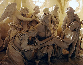
 Entombment of Christ, sculpture by Ligier Richier (16th century), in the Church of St Étienne, in Saint-Mihiel | |
| Coordinates: 48°53′21″N 5°32′37″E / 48.8892°N 5.5436°E | |
| Country | France |
| Region | Grand Est |
| Department | Meuse |
| Arrondissement | Commercy |
| Canton | Saint-Mihiel |
| Intercommunality | Sammiellois |
| Government | |
| • Mayor (2020–2026) | Xavier Cochet[1] |
Area 1 | 33 km2 (13 sq mi) |
| Population (2022)[2] | 3,848 |
| • Density | 120/km2 (300/sq mi) |
| Time zone | UTC+01:00 (CET) |
| • Summer (DST) | UTC+02:00 (CEST) |
| INSEE/Postal code | 55463 /55300 |
| Elevation | 228 m (748 ft) |
| 1 French Land Register data, which excludes lakes, ponds, glaciers > 1 km2 (0.386 sq mi or 247 acres) and river estuaries. | |
Saint-Mihiel (French pronunciation: [sɛ̃ mijɛl]) is a commune in the Meuse department in the Grand Est region in Northeastern France.[3]
Geography
[edit]Saint-Mihiel lies on the banks of the river Meuse.
History
[edit]A Benedictine abbey was established here in 708 or 709 by Count Wulfoalde and his wife Adalsinde. The library, containing over 9,000 works, is still on the original site.
During World War I, Saint-Mihiel was captured by the Germans in 1914, and was recaptured during the Battle of Saint-Mihiel by the American Expeditionary Forces (AEF) from 12 September to 19 September 1918.
Demographics
[edit]| Year | Pop. | ±% p.a. |
|---|---|---|
| 1968 | 5,295 | — |
| 1975 | 5,572 | +0.73% |
| 1982 | 5,525 | −0.12% |
| 1990 | 5,367 | −0.36% |
| 1999 | 5,260 | −0.22% |
| 2007 | 4,816 | −1.10% |
| 2012 | 4,339 | −2.06% |
| 2017 | 4,112 | −1.07% |
| Source: INSEE[4] | ||
Features
[edit]Saint-Mihiel is known for its sculptures by Renaissance sculptor Ligier Richier (1500–1567).
Saint-Mihiel serves both as the starting and ending point of the 2014 video game Valiant Hearts: The Great War.
See also
[edit]- Communes of the Meuse department
- Léopold Durand
- Sculptures by Ligier Richier
- List of World War I memorials and cemeteries in the area of the St Mihiel salient
References
[edit]- ^ "Répertoire national des élus: les maires" (in French). data.gouv.fr, Plateforme ouverte des données publiques françaises. 13 September 2022.
- ^ (in French). The National Institute of Statistics and Economic Studies. 19 December 2024 https://www.insee.fr/fr/statistiques/8288323?geo=COM-55463.
{{cite web}}: Missing or empty|title=(help) - ^ INSEE commune file
- ^ Population en historique depuis 1968, INSEE.
External links
[edit]


